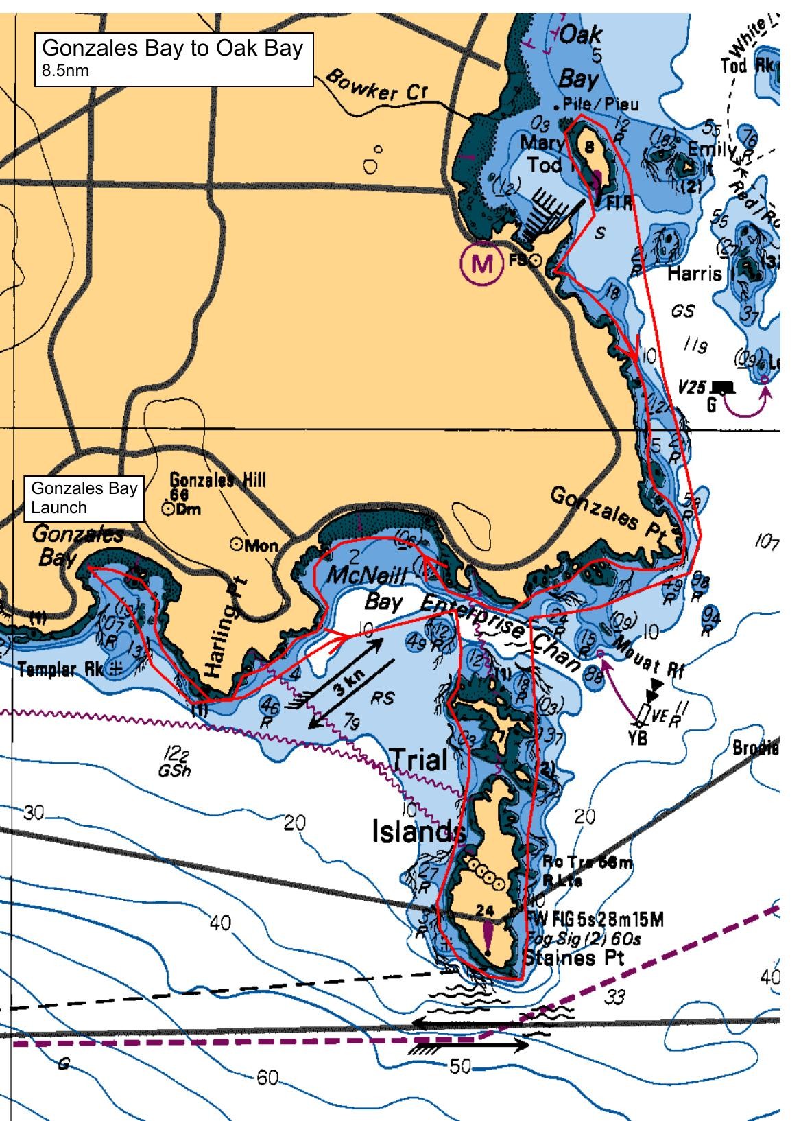
Sandy Senyk and Tony Copping will lead two pods of paddlers, to comply with SISKA’s COVID-19 protocols. This relaxed paddle will follow the shoreline out of Gonzales Bay, past Harling Point and the historic Chinese cemetery, across McNeill Bay and around Gonzales Point to our lunch stop in the little bay south of Oak Bay Marina. Current predictions are light so your paddle leader may elect to divert to the nearest island of the Trial Island Group, but only if wind and sea state conform with our Relaxed Paddle guidelines. Note: the plot indicates a trip around the outside the Trial Islands; we will not be following that route.
Route plan B
If the southwesterlies don’t co-operate, we will move to launch at Telegraph Cove and do a shoreline paddle toward Cormorant Point.
Safety reminders
Always dress for the possibility of immersion and please bring a drybag containing a spare change of clothes. The drybag goes in your kayak with you, not in your car at the launch site. Please bring a lunch or snacks and sufficient beverage to keep you hydrated, as well as a thermos of something warm. Your paddle leader will introduce the plan and make sure everyone is comfortable with the requirements. Please stay off the water until the group is ready. If you have a VHF radio please bring it with you.
SISKA · Paddle · Relaxed
Printed Nov 9, 2026 11:21 AM · siska.ca/activities/1155
Gonzales Bay to Oak Bay Marina
Sunday, July 12, 2020 · 9:30 AM – 3:30 PM
Launch
Gonzales BayRoss Street, Victoria
Destination
Oak Bay Marina
Distance
8.5 nm
Leader
Alexander Senyk
Route plan A
Sandy Senyk and Tony Copping will lead two pods of paddlers, to comply with SISKA’s COVID-19 protocols. This relaxed paddle will follow the shoreline out of Gonzales Bay, past Harling Point and the historic Chinese cemetery, across McNeill Bay and around Gonzales Point to our lunch stop in the little bay south of Oak Bay Marina. Current predictions are light so your paddle leader may elect to divert to the nearest island of the Trial Island Group, but only if wind and sea state conform with our Relaxed Paddle guidelines. Note: the plot indicates a trip around the outside the Trial Islands; we will not be following that route.
Route plan B
If the southwesterlies don’t co-operate, we will move to launch at Telegraph Cove and do a shoreline paddle toward Cormorant Point.
Route map
Gonzales Bay to Oak Bay Marina · Sunday, July 12, 2020