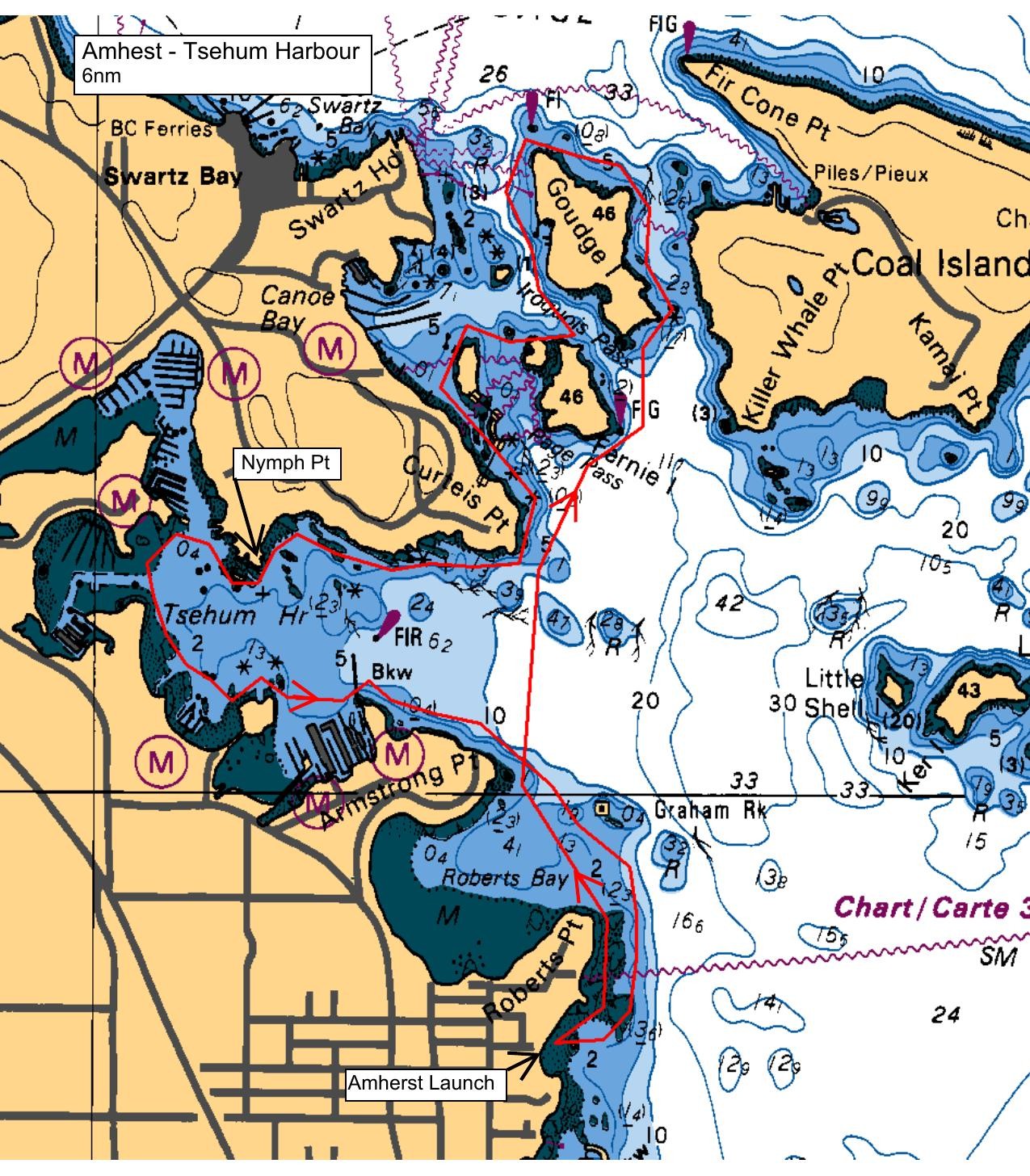
We will be launching from the sand beach below the stairs at the foot of Amherst Ave. After our beach talk and introductions, we will paddle north along the shoreline to the breakwater at the mouth of the Tsehum boat basin and then across the harbour. We'll explore the north shore and paddle toward Curteis Pt. Depending on time and group interest, we may continue up toward Fernie and Goudge Islands. It will be important that we keep together as this is a high traffic area and we want to be respectful in sharing the water.
We'll return the same way, exploring the marinas and shoreline as time and traffic allow.
Route plan B
We may choose to abbreviate the paddle by limiting the time we spend exploring Roberts Bay and Tsehum Harbour, depending on our pace and conditions. I'll continue to track the weather and contact you by e-mail if the forecast winds are cause for concern.
Safety reminders
Always dress for the possibility of immersion and please bring a drybag containing a spare change of clothes. The drybag goes in your kayak with you, not in your car at the launch site. Please bring a lunch or snacks and sufficient beverage to keep you hydrated, as well as a thermos of something warm. Your paddle leader will introduce the plan and make sure everyone is comfortable with the requirements. Please stay off the water until the group is ready. If you have a VHF radio please bring it with you.
SISKA · Paddle · Light
Printed Nov 9, 2026 11:21 AM · siska.ca/activities/1223
Amherst to Shoreline Exploration
Saturday, May 29, 2021 · 9:30 AM – 3:30 PM
Launch
Amherst10181 Wildflower Pl
Destination
Shoreline Exploration
Distance
6 nm
Leader
Jim Lamb
Route plan A
We will be launching from the sand beach below the stairs at the foot of Amherst Ave. After our beach talk and introductions, we will paddle north along the shoreline to the breakwater at the mouth of the Tsehum boat basin and then across the harbour. We'll explore the north shore and paddle toward Curteis Pt. Depending on time and group interest, we may continue up toward Fernie and Goudge Islands. It will be important that we keep together as this is a high traffic area and we want to be respectful in sharing the water.
We'll return the same way, exploring the marinas and shoreline as time and traffic allow.
Route plan B
We may choose to abbreviate the paddle by limiting the time we spend exploring Roberts Bay and Tsehum Harbour, depending on our pace and conditions. I'll continue to track the weather and contact you by e-mail if the forecast winds are cause for concern.
Route map
Amherst to Shoreline Exploration · Saturday, May 29, 2021