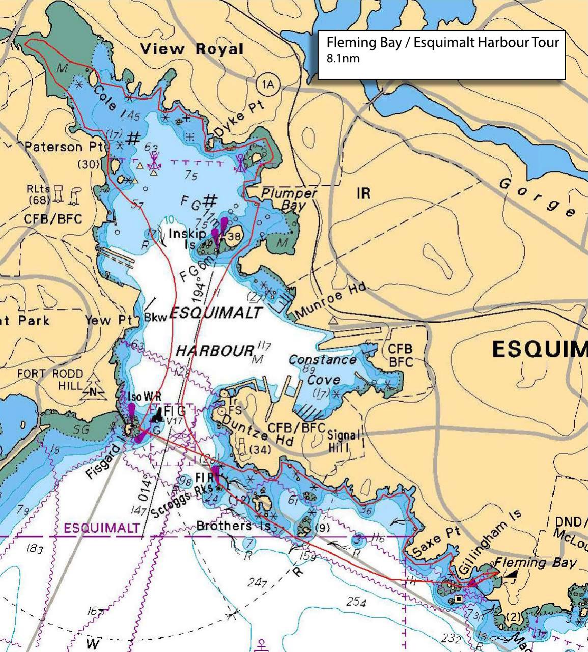
New members welcome! After all the kayaks are ready to launch and we have had a briefing, we'll head out of Fleming Beach past Sale Point Park and Brothers Islands and into Esquimalt Harbour. Keeping a safe distance from the Navy Base, we'll paddle to Cole Island and stop for a visit. As the tide will be high(ish) at +/- 2.0m, we may be able to get up into Millstream Creek for a look. Then, a leisurely paddle back to Fleming beach. The whole trip will take about 3-3.5 hours. We won't have a lunch break on the water, but bring something and we can find a place at Fleming's Beach for a picnic and a debrief (if that seems like fun)
Route plan B
TBA
Safety reminders
Always dress for the possibility of immersion and please bring a drybag containing a spare change of clothes. The drybag goes in your kayak with you, not in your car at the launch site. Please bring a lunch or snacks and sufficient beverage to keep you hydrated, as well as a thermos of something warm. Your paddle leader will introduce the plan and make sure everyone is comfortable with the requirements. Please stay off the water until the group is ready. If you have a VHF radio please bring it with you.
SISKA · Paddle · Light
Printed Nov 9, 2026 11:13 AM · siska.ca/activities/1329
Fleming Beach to Esquimalt foreshore - COASTLINE
Thursday, September 29, 2022 · 9:30 AM – 3:30 PM
Launch
Fleming Beach1101 Munro St, Victoria, BC V9A 5P2
Destination
Esquimalt foreshore
Distance
8.1 nm
Leader
Greg Rooney
Route plan A
New members welcome! After all the kayaks are ready to launch and we have had a briefing, we'll head out of Fleming Beach past Sale Point Park and Brothers Islands and into Esquimalt Harbour. Keeping a safe distance from the Navy Base, we'll paddle to Cole Island and stop for a visit. As the tide will be high(ish) at +/- 2.0m, we may be able to get up into Millstream Creek for a look. Then, a leisurely paddle back to Fleming beach. The whole trip will take about 3-3.5 hours. We won't have a lunch break on the water, but bring something and we can find a place at Fleming's Beach for a picnic and a debrief (if that seems like fun)
Route plan B
TBA
Route map
Fleming Beach to Esquimalt foreshore - COASTLINE · Thursday, September 29, 2022