Paddle Relaxed

Brentwood Bay Ferry Wharf to Coles Bay - RAFT UP - RE-LOCATED DUE TO WIND

When Saturday, June 1, 2024 9:30 AM – 3:30 PM
Location Brentwood Bay Ferry Wharf
3 of 9 open Free
Destination Coles Bay
Trip style Day
Experience Level 1
Distance 8.25 nm
Route plan A

Raft Up with Nanaimo Paddlers Club ... We will paddle out of Telegraph Cove and poke along the shoreline towards Glencoe Cove, Gordon Point, and stopping at Cormorant Point. We will watch for seals and seabirds along the way, passing some interesting sea-caves. Expect lunch at either Margaret's Bay or Glencoe Cove Park before noodling our way back to Telegraph cove. Current shouldn't be a factor with expected flood current at Race Rocks maxing out at just over 2 kts (http://www.dairiki.org/tides/daily.php/rac/2024-06-01) at about 10am slowing to slack around 1pm -- Baynes Channel runs about 75% of Race Rocks current. No washroom facilities at Telegraph Cove or Glencoe Cove. Please note: some of the available spaces will be held for guest paddlers from the Nanaimo club ... SISKA member confirmations will come out the week before the planned paddle. Anyone with questions please contact the Paddle Leader.

Route plan B

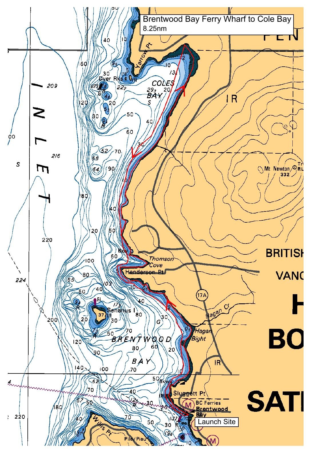
Going with Plan B due to winds along Gordon Head shoreline --- launching at the Brentwood Bay ferry dock paddling north along the shoreline to Coles Bay and return. Total distance approx 8 nautical miles.

Safety reminders

Always dress for the possibility of immersion and please bring a drybag containing a spare change of clothes. The drybag goes in your kayak with you, not in your car at the launch site. Please bring a lunch or snacks and sufficient beverage to keep you hydrated, as well as a thermos of something warm. Your paddle leader will introduce the plan and make sure everyone is comfortable with the requirements. Please stay off the water until the group is ready. If you have a VHF radio please bring it with you.

Brentwood Bay Ferry Wharf tide/current reference

Sources & licences

Tide & current predictions

CHS provides tide heights and current predictions. Secondary current stations are estimates; large-tide estimates are identified separately. Tide turns and slack water are independent. Conditions along the route vary with location.

CHS atlas & lookup licences

Canadian Atlas of Tidal Currents, Volume 3: Juan de Fuca Strait to Strait of Georgia (2016), Canadian Hydrographic Service, Fisheries and Oceans Canada. © Her Majesty the Queen in Right of Canada, 2022.

Map images are reproduced from the CHS publication and selected for the date and time shown. The publication permits noncommercial reproduction in any format; commercial reproduction requires prior written permission from CHS. This viewer is not an official CHS publication and is not to be used for navigation.

Current Atlas Lookup Tables: Juan de Fuca Strait to Strait of Georgia by Emanuel Borsboom. SISKA adapts the tables to show selected hours and atlas page numbers. The original tables and these adapted tables are provided under Creative Commons Attribution-NonCommercial-ShareAlike 2.5 Canada (CC BY-NC-SA 2.5 CA).

Dewey atlas attribution

Salish Sea Tidal Current Atlas and calendar lookup tables by Richard K. Dewey, self-published. The selected volume and map number are shown in the viewer. SISKA displays extracted map images and selects them using the author's lookup tables.

For recreational reference only. Not for navigation. These products are not endorsed by CHS or NOAA and are not official Canadian or US government publications. Use current official charts and publications for navigation.

Confirm

Confirm action

Are you sure?

SISKA · Paddle · Relaxed

Printed Nov 9, 2026 11:13 AM · siska.ca/activities/1468

Brentwood Bay Ferry Wharf to Coles Bay - RAFT UP - RE-LOCATED DUE TO WIND

Saturday, June 1, 2024 · 9:30 AM – 3:30 PM

Launch
Brentwood Bay Ferry WharfVerdier Avenue, British Columbia
Destination
Coles Bay
Distance
8.25 nm
Leader
Craig Thomson

Route plan A

Raft Up with Nanaimo Paddlers Club ... We will paddle out of Telegraph Cove and poke along the shoreline towards Glencoe Cove, Gordon Point, and stopping at Cormorant Point. We will watch for seals and seabirds along the way, passing some interesting sea-caves. Expect lunch at either Margaret's Bay or Glencoe Cove Park before noodling our way back to Telegraph cove. Current shouldn't be a factor with expected flood current at Race Rocks maxing out at just over 2 kts (http://www.dairiki.org/tides/daily.php/rac/2024-06-01) at about 10am slowing to slack around 1pm -- Baynes Channel runs about 75% of Race Rocks current. No washroom facilities at Telegraph Cove or Glencoe Cove. Please note: some of the available spaces will be held for guest paddlers from the Nanaimo club ... SISKA member confirmations will come out the week before the planned paddle. Anyone with questions please contact the Paddle Leader.

Route plan B

Going with Plan B due to winds along Gordon Head shoreline --- launching at the Brentwood Bay ferry dock paddling north along the shoreline to Coles Bay and return. Total distance approx 8 nautical miles.