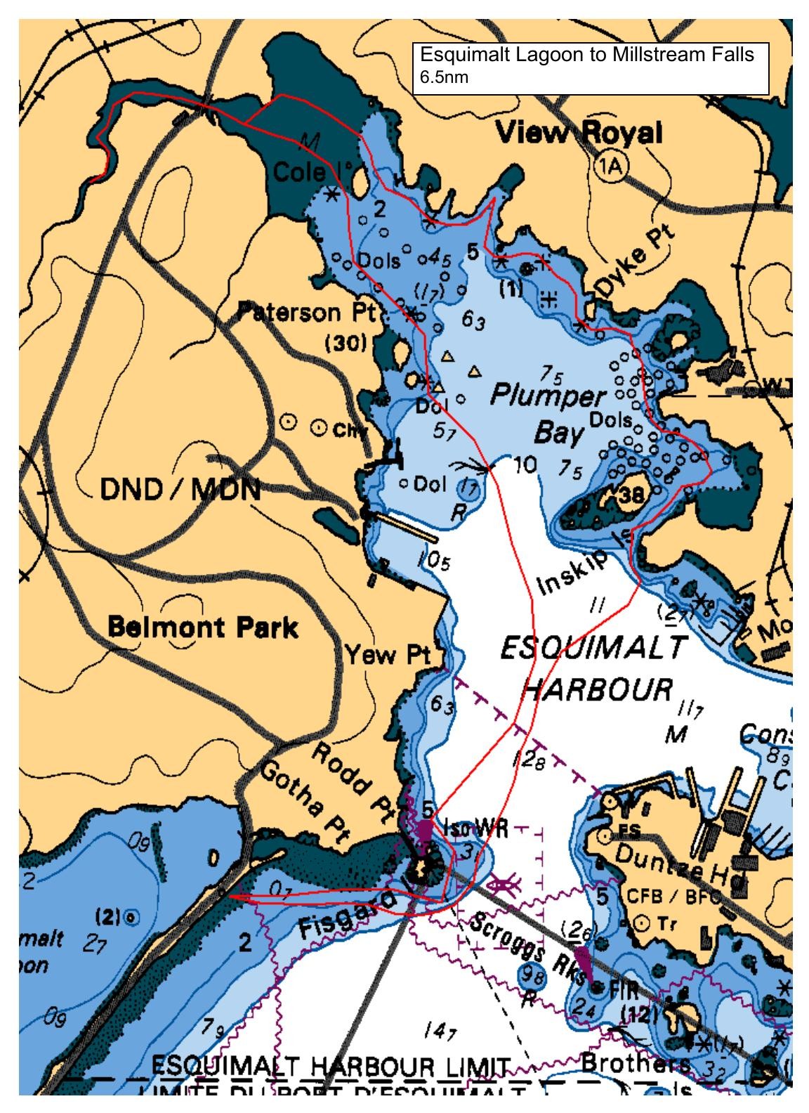
Launch will be from the North end of the lagoon, lots of parking, but washroom will be at other end. The plan will be to head towards Cole Island, with a stop if folks want, then travel along all the little coves and inlets to Portage park for lunch, then after, head back towards Fisgard Lighthouse and home. We have a low tide of 7.1ft at 10:38AM, so lots of water, and it goes to 8.9ft at 5:47PM, so a light flood all day..
NOTE: The plot is not all the way into Millstream up to the falls, a bit abbreviated. The paddle will be closer to 6nm, maybe a bit less..
Route plan B
no plan 'B' at present, as we can avoid some of the weather in this protected spot. If it does whip up, we can look at the Gorge, launching at the VCKC on Gorge Rd.
Safety reminders
Always dress for the possibility of immersion and please bring a drybag containing a spare change of clothes. The drybag goes in your kayak with you, not in your car at the launch site. Please bring a lunch or snacks and sufficient beverage to keep you hydrated, as well as a thermos of something warm. Your paddle leader will introduce the plan and make sure everyone is comfortable with the requirements. Please stay off the water until the group is ready. If you have a VHF radio please bring it with you.
SISKA · Paddle · Relaxed
Printed Nov 9, 2026 11:21 AM · siska.ca/activities/1506
Esquimalt Lagoon to Esquimalt Harbour - TRIP LEADER SICK
Sunday, September 22, 2024 · 9:30 AM – 3:30 PM
Cancelled
Launch
Esquimalt LagoonCoburg Pennisula
Destination
Esquimalt Harbour
Leader
Rod Stiebel
Route plan A
Launch will be from the North end of the lagoon, lots of parking, but washroom will be at other end. The plan will be to head towards Cole Island, with a stop if folks want, then travel along all the little coves and inlets to Portage park for lunch, then after, head back towards Fisgard Lighthouse and home. We have a low tide of 7.1ft at 10:38AM, so lots of water, and it goes to 8.9ft at 5:47PM, so a light flood all day..
NOTE: The plot is not all the way into Millstream up to the falls, a bit abbreviated. The paddle will be closer to 6nm, maybe a bit less..
Route plan B
no plan 'B' at present, as we can avoid some of the weather in this protected spot. If it does whip up, we can look at the Gorge, launching at the VCKC on Gorge Rd.
Route map
Esquimalt Lagoon to Esquimalt Harbour - TRIP LEADER SICK · Sunday, September 22, 2024