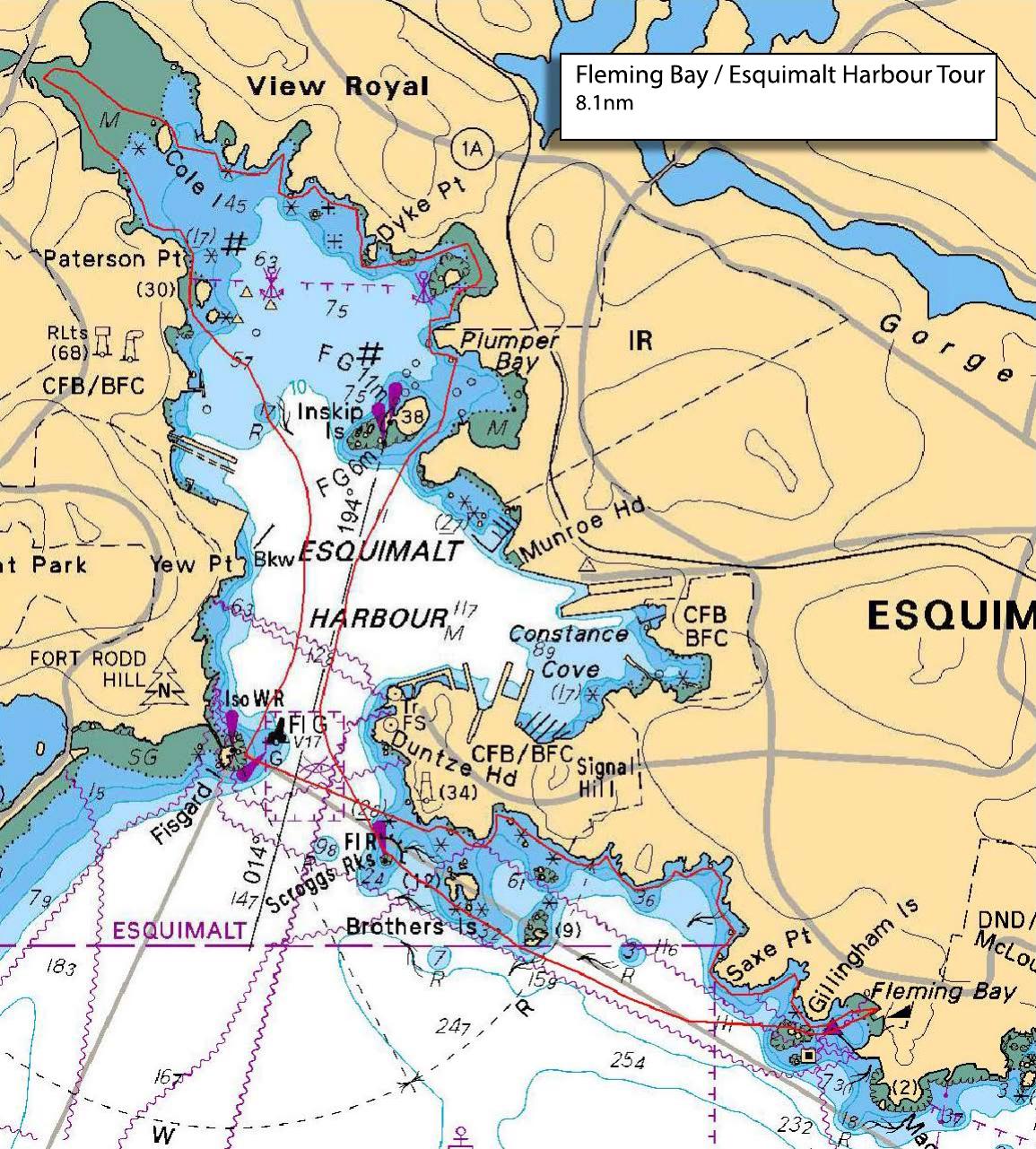
Trip leader radio Harbour Master on Channel 10 when entering and leaving Esquimalt Harbour.
If you plan to land at Fisgard Lighthouse, please make it very clear to participants that they should NOT go above the high tide line. If they do, they are subject to the normal admission fee to the park. We stay below the high tide line to avoid this source of conflict with park staff. There is a small tide rise during the time we are paddling, so currents will be low and there might be enough water to peak into Millstream estuary and lower stream (salmon allowing).
Route plan B
This route is pretty protected, but in the event that I judge the Fleming end of it to be iffy for people with lesser skills or experience, I'll revise the launch to Craigflower School park. We can go down the Gorge from there to Tillicum and then back up to Portage Inlet
Safety reminders
Always dress for the possibility of immersion and please bring a drybag containing a spare change of clothes. The drybag goes in your kayak with you, not in your car at the launch site. Please bring a lunch or snacks and sufficient beverage to keep you hydrated, as well as a thermos of something warm. Your paddle leader will introduce the plan and make sure everyone is comfortable with the requirements. Please stay off the water until the group is ready. If you have a VHF radio please bring it with you.
SISKA · Paddle · Relaxed
Printed Nov 9, 2026 11:13 AM · siska.ca/activities/1585
Fleming Beach to Esquimalt Harbour
Saturday, November 8, 2025 · 9:30 AM – 3:30 PM
Launch
Fleming Beach1101 Munro St, Victoria, BC V9A 5P2
Destination
Esquimalt Harbour
Distance
8.1 nm
Leader
Morley Eldridge
Route plan A
Trip leader radio Harbour Master on Channel 10 when entering and leaving Esquimalt Harbour.
If you plan to land at Fisgard Lighthouse, please make it very clear to participants that they should NOT go above the high tide line. If they do, they are subject to the normal admission fee to the park. We stay below the high tide line to avoid this source of conflict with park staff. There is a small tide rise during the time we are paddling, so currents will be low and there might be enough water to peak into Millstream estuary and lower stream (salmon allowing).
Route plan B
This route is pretty protected, but in the event that I judge the Fleming end of it to be iffy for people with lesser skills or experience, I'll revise the launch to Craigflower School park. We can go down the Gorge from there to Tillicum and then back up to Portage Inlet
Route map
Fleming Beach to Esquimalt Harbour · Saturday, November 8, 2025