Paddle Relaxed

Fleming Beach to Esquimalt Harbour/Cole Island/Portage Park

When Saturday, February 14, 2026 9:30 AM – 3:30 PM
Location Fleming Beach
3 of 9 open Free
Destination Esquimalt Harbour/Cole Island/Portage Park
Trip style Day
Experience Basic
Distance 8.1 nm
Route plan A

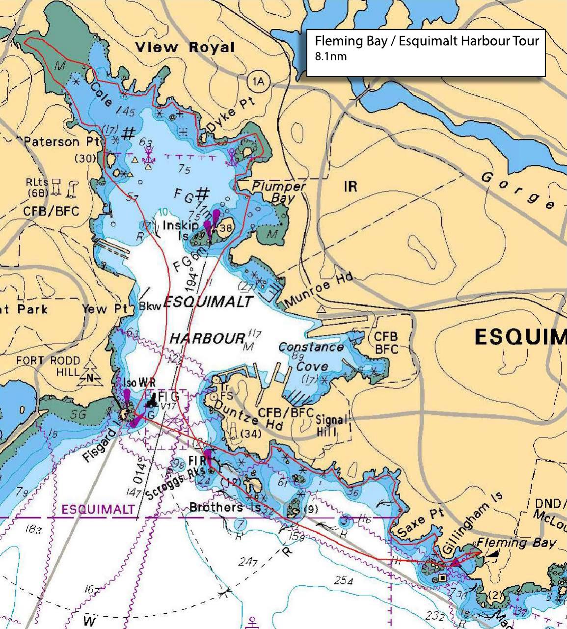
Follow the Esquimalt shoreline from Fleming Bay (Esquimalt Anglers) around past Saxe Point to the entrance of Esquimalt Harbour, crossing to Fisgard Lighthouse before contacting the King's Harbour Master on VHF ch10 and entering the restricted harbour. Staying clear of naval installations we proceed down the middle of the harbour past Cole Island to the 6-Mile Bridge before turning back passing Cole Island again. We will stop for a snack and stretch at Portage Park beach in Thetis Cove, then cross the mouth of the naval harbour before exiting Esquimalt Harbour at Duntze Head, passing alongside Brothers Islands, and returning to Fleming Bay.

There is ample free parking and heated washroom facilities at Fleming Bay.

Please ensure that access to the Esquimalt Anglers boat launch ramp is unobstructed when loading and unloading your vehicles. Park vehicles and carry kayaks to the launch beach to the right of the boat ramp.

There may be opportunity for a post-paddle debrief at Serious Coffee in Esquimalt adjacent to the Esquimalt Bakery (yummy!).

Tide and current impact should be minimal with tide at Esquimalt Harbour ebbing throughout the paddle window falling from 2.7M at 1000hrs to 2.2M at 1400hrs. Current at Race Rocks (closest station) shows a slight ebb of 1kt at 1000hrs slowing to slack at 1200hrs before turning back to ebb of 2kts by 1400hrs.

Anyone with questions please contact the paddle leader by email at CST4420@TELUS.NET **DO NOT REPLY TO THIS SISKA EMAIL**

Route plan B

Opted for Brentwood Bay to Coles Bay due to wind conditions at Plan A location.

Safety reminders

Always dress for the possibility of immersion and please bring a drybag containing a spare change of clothes. The drybag goes in your kayak with you, not in your car at the launch site. Please bring a lunch or snacks and sufficient beverage to keep you hydrated, as well as a thermos of something warm. Your paddle leader will introduce the plan and make sure everyone is comfortable with the requirements. Please stay off the water until the group is ready. If you have a VHF radio please bring it with you.

Fleming Beach tide/current reference

Sources & licences

Tide & current predictions

CHS provides tide heights and current predictions. Secondary current stations are estimates; large-tide estimates are identified separately. Tide turns and slack water are independent. Conditions along the route vary with location.

CHS atlas & lookup licences

Canadian Atlas of Tidal Currents, Volume 3: Juan de Fuca Strait to Strait of Georgia (2016), Canadian Hydrographic Service, Fisheries and Oceans Canada. © Her Majesty the Queen in Right of Canada, 2022.

Map images are reproduced from the CHS publication and selected for the date and time shown. The publication permits noncommercial reproduction in any format; commercial reproduction requires prior written permission from CHS. This viewer is not an official CHS publication and is not to be used for navigation.

Current Atlas Lookup Tables: Juan de Fuca Strait to Strait of Georgia by Emanuel Borsboom. SISKA adapts the tables to show selected hours and atlas page numbers. The original tables and these adapted tables are provided under Creative Commons Attribution-NonCommercial-ShareAlike 2.5 Canada (CC BY-NC-SA 2.5 CA).

Dewey atlas attribution

Salish Sea Tidal Current Atlas and calendar lookup tables by Richard K. Dewey, self-published. The selected volume and map number are shown in the viewer. SISKA displays extracted map images and selects them using the author's lookup tables.

For recreational reference only. Not for navigation. These products are not endorsed by CHS or NOAA and are not official Canadian or US government publications. Use current official charts and publications for navigation.

Confirm

Confirm action

Are you sure?

SISKA · Paddle · Relaxed

Printed Nov 8, 2026 9:31 AM · siska.ca/activities/1610

Fleming Beach to Esquimalt Harbour/Cole Island/Portage Park

Saturday, February 14, 2026 · 9:30 AM – 3:30 PM

Launch
Fleming Beach1101 Munro St, Victoria, BC V9A 5P2
Destination
Esquimalt Harbour/Cole Island/Portage Park
Distance
8.1 nm
Leader
Craig Thomson

Route plan A

Follow the Esquimalt shoreline from Fleming Bay (Esquimalt Anglers) around past Saxe Point to the entrance of Esquimalt Harbour, crossing to Fisgard Lighthouse before contacting the King's Harbour Master on VHF ch10 and entering the restricted harbour. Staying clear of naval installations we proceed down the middle of the harbour past Cole Island to the 6-Mile Bridge before turning back passing Cole Island again. We will stop for a snack and stretch at Portage Park beach in Thetis Cove, then cross the mouth of the naval harbour before exiting Esquimalt Harbour at Duntze Head, passing alongside Brothers Islands, and returning to Fleming Bay.

There is ample free parking and heated washroom facilities at Fleming Bay.

Please ensure that access to the Esquimalt Anglers boat launch ramp is unobstructed when loading and unloading your vehicles. Park vehicles and carry kayaks to the launch beach to the right of the boat ramp.

There may be opportunity for a post-paddle debrief at Serious Coffee in Esquimalt adjacent to the Esquimalt Bakery (yummy!).

Tide and current impact should be minimal with tide at Esquimalt Harbour ebbing throughout the paddle window falling from 2.7M at 1000hrs to 2.2M at 1400hrs. Current at Race Rocks (closest station) shows a slight ebb of 1kt at 1000hrs slowing to slack at 1200hrs before turning back to ebb of 2kts by 1400hrs.

Anyone with questions please contact the paddle leader by email at CST4420@TELUS.NET **DO NOT REPLY TO THIS SISKA EMAIL**

Route plan B

Opted for Brentwood Bay to Coles Bay due to wind conditions at Plan A location.