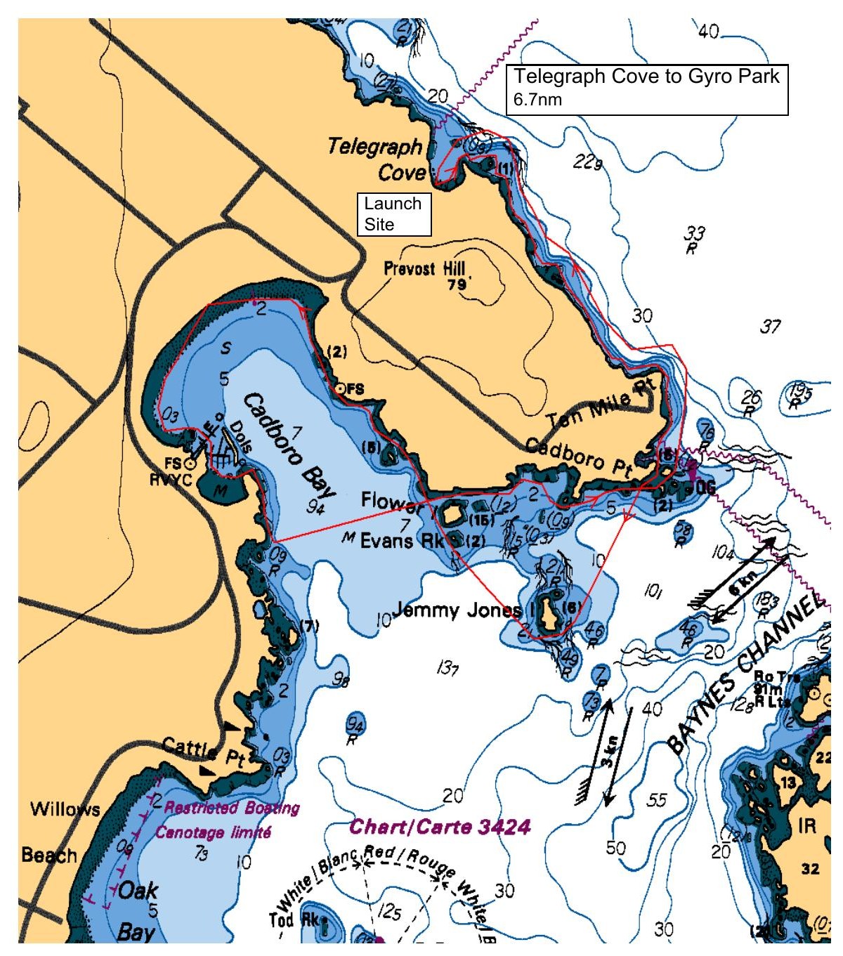
Option 1: Assisted by a light ebb and a light flood, depart Telegraph Cove and follow the coast around Ten Mile Point, into Cadboro Bay and possibly the islets near The Uplands. Lunch at Cadboro Gyro Park and a return ride on the current back to Telegraph Cove.
Option 2: Depart from Cadboro Bay / Gyro Park following the shoreline to Cattle Point and Willows Beach, circumnavigate Mary Tod Island stopping for lunch at Willows beach before crossing the entrance to Cadboro Bay to Flower Island, paddling to Cadboro Point and noodling back to Gyro Park (about 6 nautical miles).
Final decision to be made closer to paddle day.
Route plan B
TBA
Safety reminders
Always dress for the possibility of immersion and please bring a drybag containing a spare change of clothes. The drybag goes in your kayak with you, not in your car at the launch site. Please bring a lunch or snacks and sufficient beverage to keep you hydrated, as well as a thermos of something warm. Your paddle leader will introduce the plan and make sure everyone is comfortable with the requirements. Please stay off the water until the group is ready. If you have a VHF radio please bring it with you.
SISKA · Paddle · Relaxed
Printed Nov 8, 2026 9:31 AM · siska.ca/activities/1617
Telegraph Cove to Cadboro Gyro Park - UPLANDS
Saturday, March 14, 2026 · 9:30 AM – 3:30 PM
Launch
Telegraph Cove4040 Lockehaven Dr
Destination
Cadboro Gyro Park
Distance
6.7 nm
Leader
Craig Thomson
Route plan A
Option 1: Assisted by a light ebb and a light flood, depart Telegraph Cove and follow the coast around Ten Mile Point, into Cadboro Bay and possibly the islets near The Uplands. Lunch at Cadboro Gyro Park and a return ride on the current back to Telegraph Cove.
Option 2: Depart from Cadboro Bay / Gyro Park following the shoreline to Cattle Point and Willows Beach, circumnavigate Mary Tod Island stopping for lunch at Willows beach before crossing the entrance to Cadboro Bay to Flower Island, paddling to Cadboro Point and noodling back to Gyro Park (about 6 nautical miles).
Final decision to be made closer to paddle day.
Route plan B
TBA
Route map
Telegraph Cove to Cadboro Gyro Park - UPLANDS · Saturday, March 14, 2026