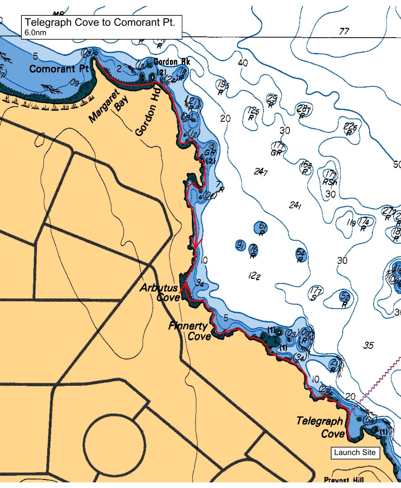
Depart Telegraph Cove (Bay) following the shoreline past Finnerty Cove, Arbutus Cove, and Glencoe Cove before rounding Gordon Head to Margaret Bay. Return following the same route. Lunch / rest stop at either Margaret Bay or Glencoe Cove. There are a couple of notable sea caves along the route, seabirds are usually plentiful, seals and sea lions have been seen.
Tide is falling throughout the paddle day which makes launching and landing at Telegraph Cove easier than dealing with very high tides. Current should be negligible with a small ebb in Baynes Channel during our paddle.
Lots of parking, but no washroom facilities at Telegraph Cove (or Margaret Bay or Glencoe Cove).
Route plan B
This route is exposed to easterly and northerly winds. Depending on the forecast for paddle day an alternative paddle may be substituted.
Safety reminders
Always dress for the possibility of immersion and please bring a drybag containing a spare change of clothes. The drybag goes in your kayak with you, not in your car at the launch site. Please bring a lunch or snacks and sufficient beverage to keep you hydrated, as well as a thermos of something warm. Your paddle leader will introduce the plan and make sure everyone is comfortable with the requirements. Please stay off the water until the group is ready. If you have a VHF radio please bring it with you.
SISKA · Paddle · Relaxed
Printed Nov 2, 2026 6:36 AM · siska.ca/activities/1623
Telegraph Cove to Margaret Bay
Saturday, April 11, 2026 · 9:30 AM – 3:30 PM
Launch
Telegraph Cove4040 Lockehaven Dr
Destination
Margaret Bay
Distance
6 nm
Leader
Craig Thomson
Route plan A
Depart Telegraph Cove (Bay) following the shoreline past Finnerty Cove, Arbutus Cove, and Glencoe Cove before rounding Gordon Head to Margaret Bay. Return following the same route. Lunch / rest stop at either Margaret Bay or Glencoe Cove. There are a couple of notable sea caves along the route, seabirds are usually plentiful, seals and sea lions have been seen.
Tide is falling throughout the paddle day which makes launching and landing at Telegraph Cove easier than dealing with very high tides. Current should be negligible with a small ebb in Baynes Channel during our paddle.
Lots of parking, but no washroom facilities at Telegraph Cove (or Margaret Bay or Glencoe Cove).
Route plan B
This route is exposed to easterly and northerly winds. Depending on the forecast for paddle day an alternative paddle may be substituted.
Route map
Telegraph Cove to Margaret Bay · Saturday, April 11, 2026