SISKA · Paddle · Relaxed
Oak Bay Marina - Parking Lot to Ten Mile Point
Saturday, October 31, 2026 · 9:30 AM – 3:30 PM
- Launch
- Oak Bay Marina - Parking Lot
- Destination
- Ten Mile Point
- Distance
- 7.6 nm
- Leader
- Craig Thomson
Tides & currents Saturday, October 31
Trip 09:30–15:30 Flood Ebb Times PDT
| 11:40 | High | 2.97 m |
| 10:07 | Slack → ebb | |
| 13:28 | Max ebb | 3.8 kts |
| 18:16 | Min ebb | 0.5 kts |
| 09:52 | Slack → ebb | |
| 13:13 | Max ebb | 2.9 kts |
| 18:01 | Min ebb | 0.4 kts |
Estimated from Race Passage
CHS predictions (tides.gc.ca) for Oak Bay Marina - Parking Lot's stations. Bold times fall within the trip. Not for navigation.
Route plan A
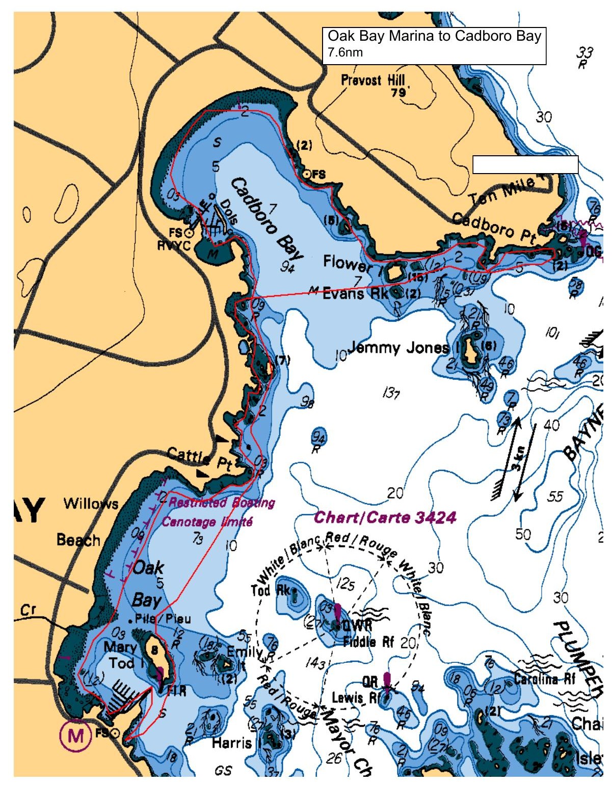
Launch from the beach to the south of Oak Bay Marina (down the stairs at the south-east corner of the Turkey Head parking lot). Paddle around the east side of Mary Tod Island then head to Cattle Point before making our way along the shoreline in Cadboro Bay. Exit Cordova Bay via tucking behind Flower Island, head to the Nav Aid at Cadboro Point before making our way back by crossing Cadboro Bay between Evans Rock and Flower Island and noodling the shore back to the launch beach. Expect to be on the water for approximately 4 hours including a rest / lunch stop along the way.
There are public washrooms available at the Oak Bay Marina.
Tides will be high all day (1000hrs 2.8M / 1400hrs 2.8M), but there should be some beach to work with at launch and return. Current in Baynes Channel is predicted to be slack at about launch time, with maximum ebb predicted for 1315hrs (-2.8 kts). Current in Baynes Channel is not expected to be an issue during the paddle as our route avoids the areas most affected by current in the main channel.
Possible post-paddle debrief at the Oak Bay Marina Coffee Shop.
Route plan B
TBA - wind forecast will determine if the paddle goes ahead as planned or relocated or ... ??
Route map
Oak Bay Marina - Parking Lot to Ten Mile Point · Saturday, October 31, 2026