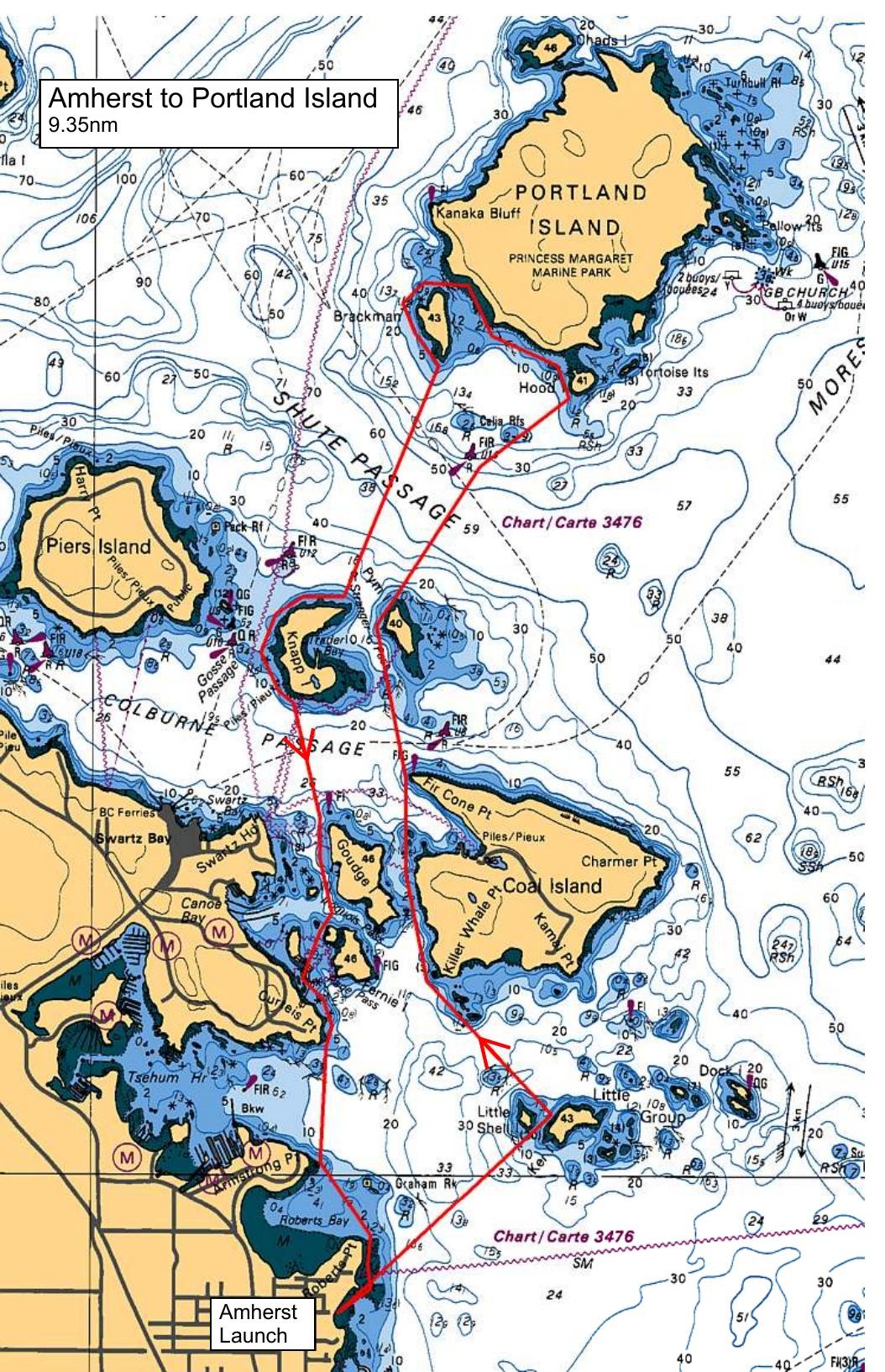
Meet at Amherst and be ready to be ON THE WATER by 10:00am. From the launch point, we will head north to the Little Group of islets and then to Killer Whale on Coal Island. From there, we will go through St John Pass to Fir Cone Pt ( Coal Island). We will pass between Pym and Knapp Islands before heading over to Royal Bay on Portland Island. We will noodle the south shore of Portland Island and then stop at Shell Beach for lunch. After lunch, back across Shute Passage to Pym and Knapp Islands and then into Iroquois Pass, past Canoe Cove and to Curteis Pt. From Curteis Pt- back across mouth of Tsehum Harbour and to our launch point at Amherst.
Route plan B
TBA
Safety reminders
Always dress for the possibility of immersion and please bring a drybag containing a spare change of clothes. The drybag goes in your kayak with you, not in your car at the launch site. Please bring a lunch or snacks and sufficient beverage to keep you hydrated, as well as a thermos of something warm. Your paddle leader will introduce the plan and make sure everyone is comfortable with the requirements. Please stay off the water until the group is ready. If you have a VHF radio please bring it with you.
SISKA · Paddle · Energizer
Printed Nov 9, 2026 11:03 AM · siska.ca/activities/1275
Amherst to Portland Island - SHELL BEACH
Saturday, February 12, 2022 · 9:30 AM – 3:30 PM
Launch
Amherst10181 Wildflower Pl
Destination
Portland Island
Distance
9.35 nm
Leader
Joanne Nicolson
Route plan A
Meet at Amherst and be ready to be ON THE WATER by 10:00am. From the launch point, we will head north to the Little Group of islets and then to Killer Whale on Coal Island. From there, we will go through St John Pass to Fir Cone Pt ( Coal Island). We will pass between Pym and Knapp Islands before heading over to Royal Bay on Portland Island. We will noodle the south shore of Portland Island and then stop at Shell Beach for lunch. After lunch, back across Shute Passage to Pym and Knapp Islands and then into Iroquois Pass, past Canoe Cove and to Curteis Pt. From Curteis Pt- back across mouth of Tsehum Harbour and to our launch point at Amherst.
Route plan B
TBA
Route map
Amherst to Portland Island - SHELL BEACH · Saturday, February 12, 2022