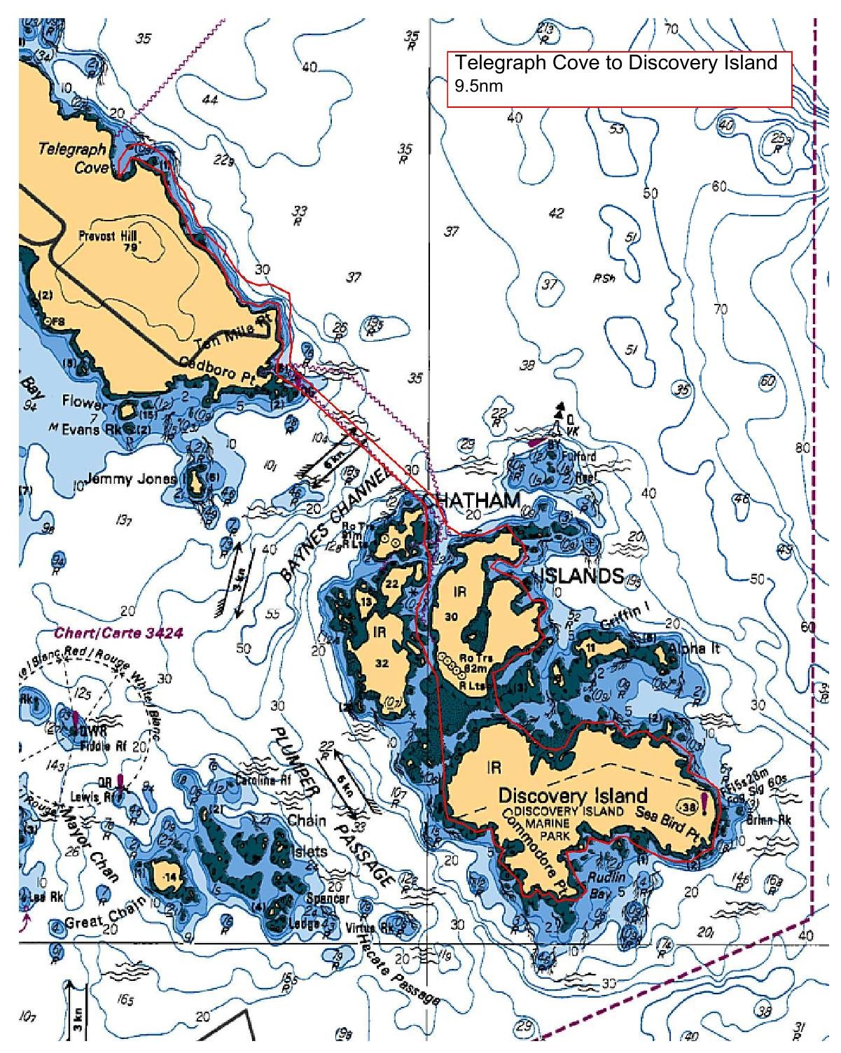
Leaving the beach at Telegraph Cove, we will noodle the Ten Mile Pt shoreline until reaching the Cadboro Pt light. We will then cross over Baynes Channel to the Fulford Reef buoy before heading south into and exploring the Chatham/Discovery Island 'archipelago'. We will then follow the eastern shoreline of Discovery Island, past the DI light station to our lunch destination at Rudin Bay.
After lunch, we will continue our clockwise tour of the DI shoreline before crossing into the channel between the two Chathan Islands. Following the CI channel, we will then paddle west through the cut near Strong Tide Island and then across Baynes Channel and back to Telegraph Cove.
Coffee and treats afterwards at Moka House in Cadboro Bay.
Route plan B
A Plan B would be determined, if required, after assessing the wind and sea state prior to the paddle launch.
Safety reminders
Always dress for the possibility of immersion and please bring a drybag containing a spare change of clothes. The drybag goes in your kayak with you, not in your car at the launch site. Please bring a lunch or snacks and sufficient beverage to keep you hydrated, as well as a thermos of something warm. Your paddle leader will introduce the plan and make sure everyone is comfortable with the requirements. Please stay off the water until the group is ready. If you have a VHF radio please bring it with you.
SISKA · Paddle · Energizer
Printed Nov 9, 2026 11:01 AM · siska.ca/activities/1505
Telegraph Cove to Discovery Island
Sunday, September 22, 2024 · 9:30 AM – 3:30 PM
Launch
Telegraph Cove4040 Lockehaven Dr
Destination
Discovery Island
Distance
9.5 nm
Leader
Dave Chater
Route plan A
Leaving the beach at Telegraph Cove, we will noodle the Ten Mile Pt shoreline until reaching the Cadboro Pt light. We will then cross over Baynes Channel to the Fulford Reef buoy before heading south into and exploring the Chatham/Discovery Island 'archipelago'. We will then follow the eastern shoreline of Discovery Island, past the DI light station to our lunch destination at Rudin Bay.
After lunch, we will continue our clockwise tour of the DI shoreline before crossing into the channel between the two Chathan Islands. Following the CI channel, we will then paddle west through the cut near Strong Tide Island and then across Baynes Channel and back to Telegraph Cove.
Coffee and treats afterwards at Moka House in Cadboro Bay.
Route plan B
A Plan B would be determined, if required, after assessing the wind and sea state prior to the paddle launch.
Route map
Telegraph Cove to Discovery Island · Sunday, September 22, 2024