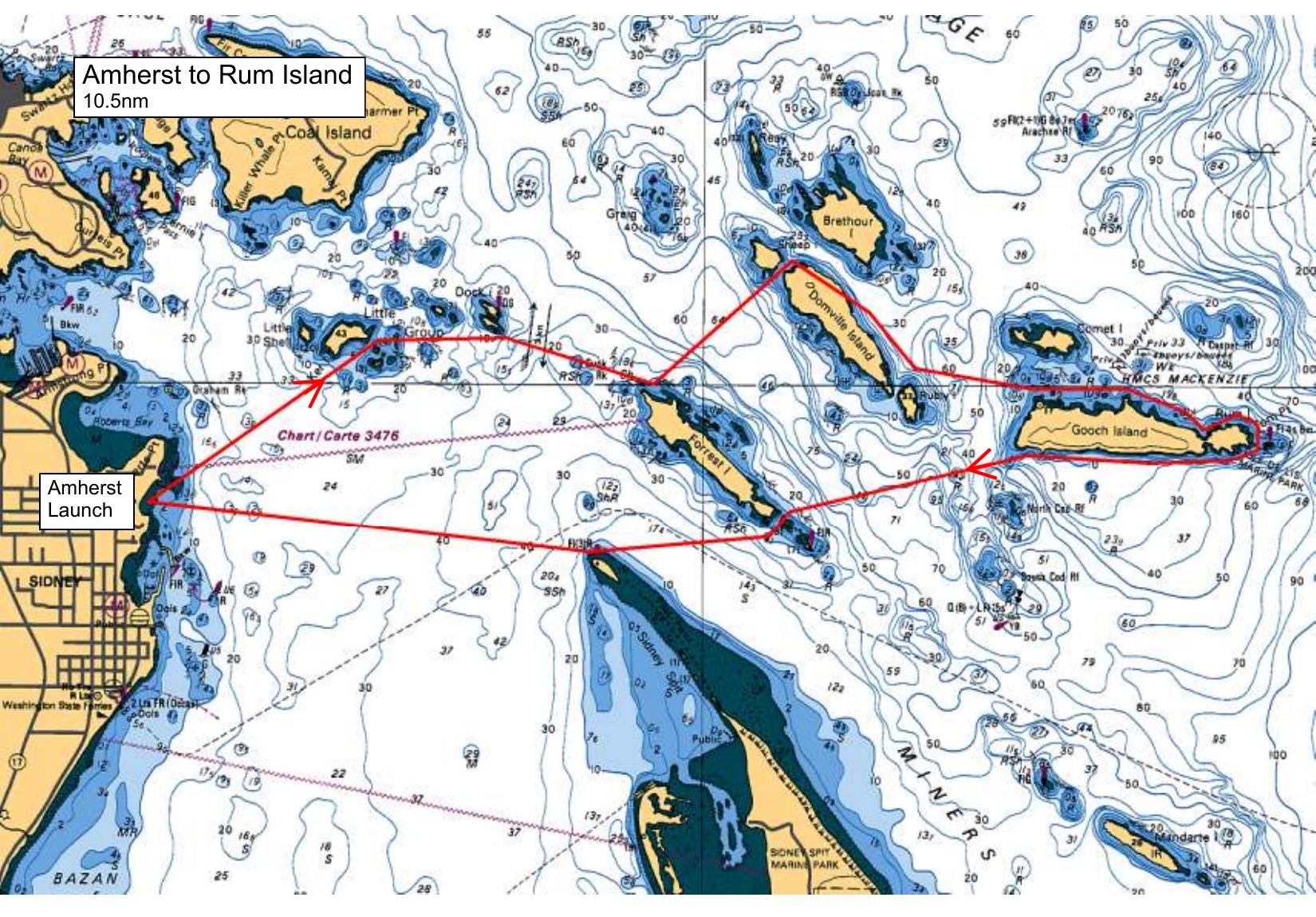
We will launch at the kayak launch on Amherst and paddle to the southern side of Dock Island. From there we will head to the northern tip of Forrest Island and follow the shore of Forrest to the end of that island. At that point we will aim up towards Ruby (between Domville and Gooch) and expect to be drawn toward a landfall at the west end of Gooch.We will follow the shores of Gooch until we reach the beautiful beach at Rum Island. After lunch, we will watch for rips just north of Ruby during the crossing from Gooch to Domville. On our return journey from Domville we will touch on Greig and Kerr Islands before reaching our launch spot.
Route plan B
Should the weather be inclement, we will launch at Patricia Bay and paddle the coastline in to Coles Bay.
Safety reminders
Always dress for the possibility of immersion and please bring a drybag containing a spare change of clothes. The drybag goes in your kayak with you, not in your car at the launch site. Please bring a lunch or snacks and sufficient beverage to keep you hydrated, as well as a thermos of something warm. Your paddle leader will introduce the plan and make sure everyone is comfortable with the requirements. Please stay off the water until the group is ready. If you have a VHF radio please bring it with you.
SISKA · Paddle · Energizer
Printed Nov 9, 2026 10:59 AM · siska.ca/activities/1534
Amherst to Rum Island
Saturday, March 22, 2025 · 9:30 AM – 3:30 PM
Launch
Amherst10181 Wildflower Pl
Destination
Rum Island
Distance
10.5 nm
Leader
Johanna De Leeuw
Route plan A
We will launch at the kayak launch on Amherst and paddle to the southern side of Dock Island. From there we will head to the northern tip of Forrest Island and follow the shore of Forrest to the end of that island. At that point we will aim up towards Ruby (between Domville and Gooch) and expect to be drawn toward a landfall at the west end of Gooch.We will follow the shores of Gooch until we reach the beautiful beach at Rum Island. After lunch, we will watch for rips just north of Ruby during the crossing from Gooch to Domville. On our return journey from Domville we will touch on Greig and Kerr Islands before reaching our launch spot.
Route plan B
Should the weather be inclement, we will launch at Patricia Bay and paddle the coastline in to Coles Bay.