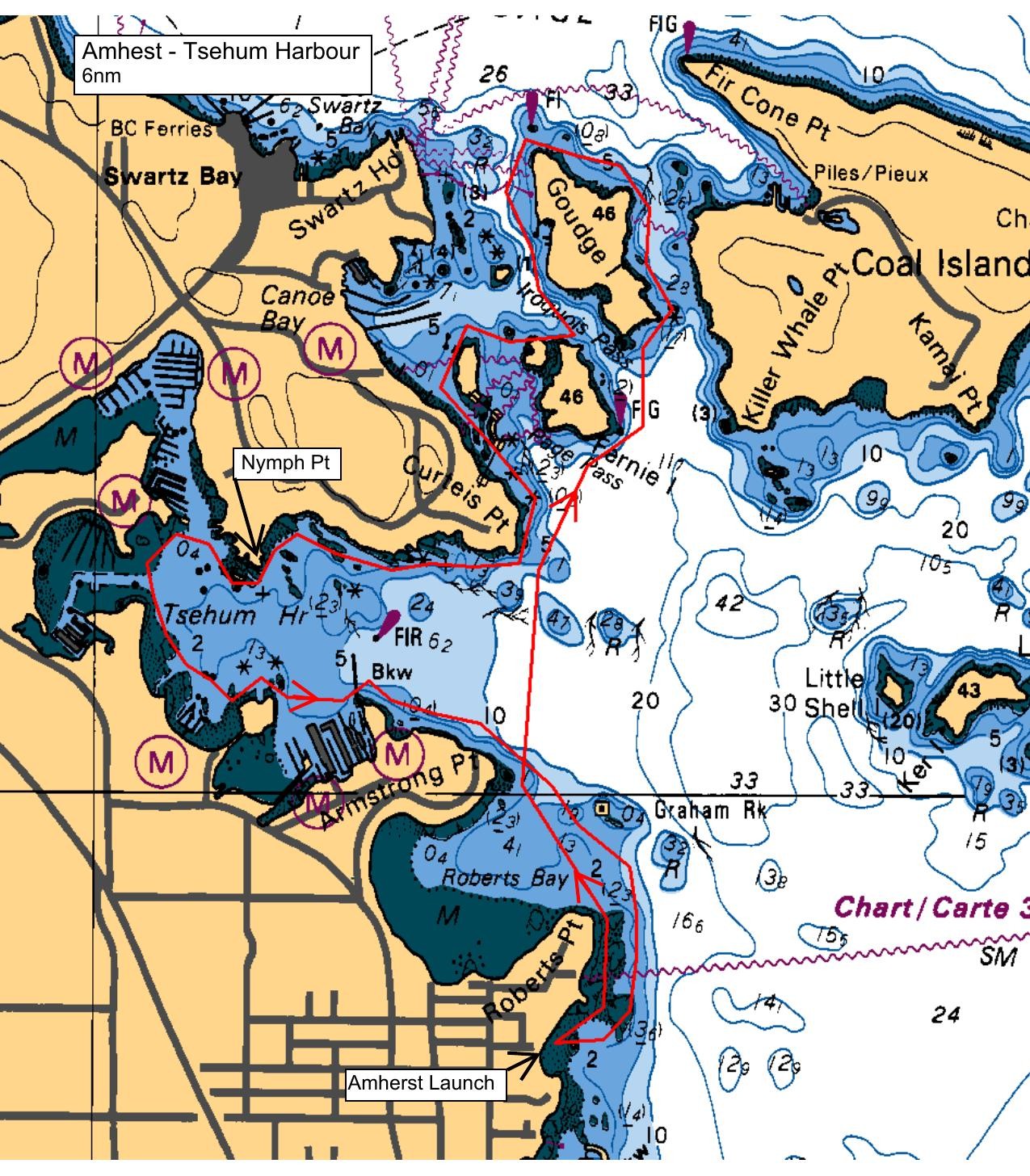
The tide will be quite low when we launch at Amherst, and we will paddle northwards along the shore to Roberts Point, then cross Roberts Bay to Armstrong Point. From there we will cross the mouth of Tsehum Harbour, a distance of about 750 meters, to Curteis Point, and then proceed to slowly circumnavigate Goudge and Fernie Islands - really lovely islands. Lunch is at a beautiful white shell grit beach on Goudge, then we'll meander back to Curteis Point., and may venture into Tsehum Harbour some distance before crossing to the south side and back to Amherst. There will be a lot intertidal life on display due to the low tide, but it also means carrying the kayaks some distance to launch and retrieve. Paddlers are encouraged to share their knowledge of local history, marine biology or anything else that might be of interest.
Route plan B
TBA
Safety reminders
Always dress for the possibility of immersion and please bring a drybag containing a spare change of clothes. The drybag goes in your kayak with you, not in your car at the launch site. Please bring a lunch or snacks and sufficient beverage to keep you hydrated, as well as a thermos of something warm. Your paddle leader will introduce the plan and make sure everyone is comfortable with the requirements. Please stay off the water until the group is ready. If you have a VHF radio please bring it with you.
SISKA · Paddle · Relaxed
Printed Nov 9, 2026 10:59 AM · siska.ca/activities/1557
Amherst to Intertidal - EXPLORATION
Saturday, June 28, 2025 · 9:15 AM – 3:15 PM
Launch
Amherst10181 Wildflower Pl
Destination
Intertidal
Distance
6 nm
Leader
Liane O'grady
Route plan A
The tide will be quite low when we launch at Amherst, and we will paddle northwards along the shore to Roberts Point, then cross Roberts Bay to Armstrong Point. From there we will cross the mouth of Tsehum Harbour, a distance of about 750 meters, to Curteis Point, and then proceed to slowly circumnavigate Goudge and Fernie Islands - really lovely islands. Lunch is at a beautiful white shell grit beach on Goudge, then we'll meander back to Curteis Point., and may venture into Tsehum Harbour some distance before crossing to the south side and back to Amherst. There will be a lot intertidal life on display due to the low tide, but it also means carrying the kayaks some distance to launch and retrieve. Paddlers are encouraged to share their knowledge of local history, marine biology or anything else that might be of interest.
Route plan B
TBA
Route map
Amherst to Intertidal - EXPLORATION · Saturday, June 28, 2025