We will leave the Beach at Gyro Park and make our way out to Cadboro Point. If conditions are suitable, we will cross Baynes Channel over to the Chatham/Discovery group and likely make a clockwise circumnavigation of the group or head through the middle of the Chatham islands. The plan would be to stop for lunch in Rudlin Bay (part of the Provincial Park. Returning via Jemmy Jones Islet.
Route plan B
Plan B could be a shoreline paddle from Gyro beach south towards Oak Bay or north towards Gordon Head. Alternatively, we might launch at Telegraph cove .
Safety reminders
Always dress for the possibility of immersion and please bring a drybag containing a spare change of clothes. The drybag goes in your kayak with you, not in your car at the launch site. Please bring a lunch or snacks and sufficient beverage to keep you hydrated, as well as a thermos of something warm. Your paddle leader will introduce the plan and make sure everyone is comfortable with the requirements. Please stay off the water until the group is ready. If you have a VHF radio please bring it with you.
SISKA · Paddle · Energizer
Printed Oct 31, 2026 9:44 PM · siska.ca/activities/1158
Cadboro Bay to Chatham/Discovery Islands
Saturday, August 8, 2020 · 9:30 AM – 3:30 PM
Launch
Cadboro Bay2600 Sinclair Rd, Victoria
Destination
Chatham/Discovery Islands
Distance
9.3 nm
Leader
Michael Jackson
Route plan A
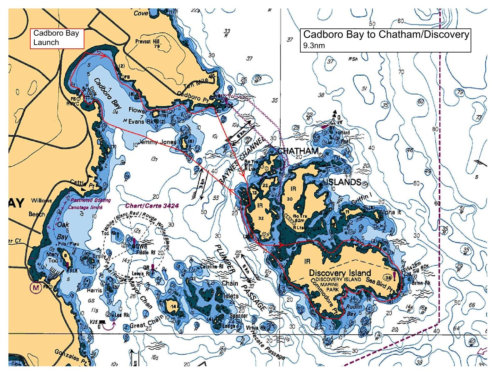
We will leave the Beach at Gyro Park and make our way out to Cadboro Point. If conditions are suitable, we will cross Baynes Channel over to the Chatham/Discovery group and likely make a clockwise circumnavigation of the group or head through the middle of the Chatham islands. The plan would be to stop for lunch in Rudlin Bay (part of the Provincial Park. Returning via Jemmy Jones Islet.
Route plan B
Plan B could be a shoreline paddle from Gyro beach south towards Oak Bay or north towards Gordon Head. Alternatively, we might launch at Telegraph cove .
Route map
Cadboro Bay to Chatham/Discovery Islands · Saturday, August 8, 2020