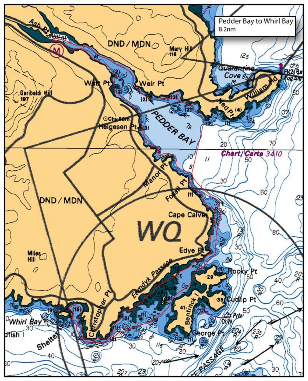
We will put in at Pedder Bay Marina. Launch fee is $10 per car.
Our usual Covid protocols will be in place, meaning we will be paddling in one or two pods of six paddlers. We will go through Eemdyk Passage between Vancouver Island and Bentinck Island. There is a mild 2 knot maximum flood near noon, and not much change in tide height. After rounding Christopher Point, we will lunch behind Shelter Island. On our return, we will paddle on the inside of Bentinck Island and then cross the mouth of Pedder Bay to paddle back on the north side of Pedder Bay.
Distance for this paddle is approximately 9.0 nm.
Route plan B
If the wind is up, we will just stick to the west side of the passage and forego the crossing
Safety reminders
Always dress for the possibility of immersion and please bring a drybag containing a spare change of clothes. The drybag goes in your kayak with you, not in your car at the launch site. Please bring a lunch or snacks and sufficient beverage to keep you hydrated, as well as a thermos of something warm. Your paddle leader will introduce the plan and make sure everyone is comfortable with the requirements. Please stay off the water until the group is ready. If you have a VHF radio please bring it with you.
SISKA · Paddle · Relaxed
Printed Nov 9, 2026 11:03 AM · siska.ca/activities/1182
Pedder Bay to Bentinck Island - INSIDE ROUTE
Saturday, November 28, 2020 · 9:30 AM – 3:30 PM
Cancelled
Launch
Pedder BayPedder Bay Road, British Columbia
Destination
Bentinck Island
Leader
Dorothea Hoffman
Route plan A
We will put in at Pedder Bay Marina. Launch fee is $10 per car.
Our usual Covid protocols will be in place, meaning we will be paddling in one or two pods of six paddlers. We will go through Eemdyk Passage between Vancouver Island and Bentinck Island. There is a mild 2 knot maximum flood near noon, and not much change in tide height. After rounding Christopher Point, we will lunch behind Shelter Island. On our return, we will paddle on the inside of Bentinck Island and then cross the mouth of Pedder Bay to paddle back on the north side of Pedder Bay.
Distance for this paddle is approximately 9.0 nm.
Route plan B
If the wind is up, we will just stick to the west side of the passage and forego the crossing
Route map
Pedder Bay to Bentinck Island - INSIDE ROUTE · Saturday, November 28, 2020