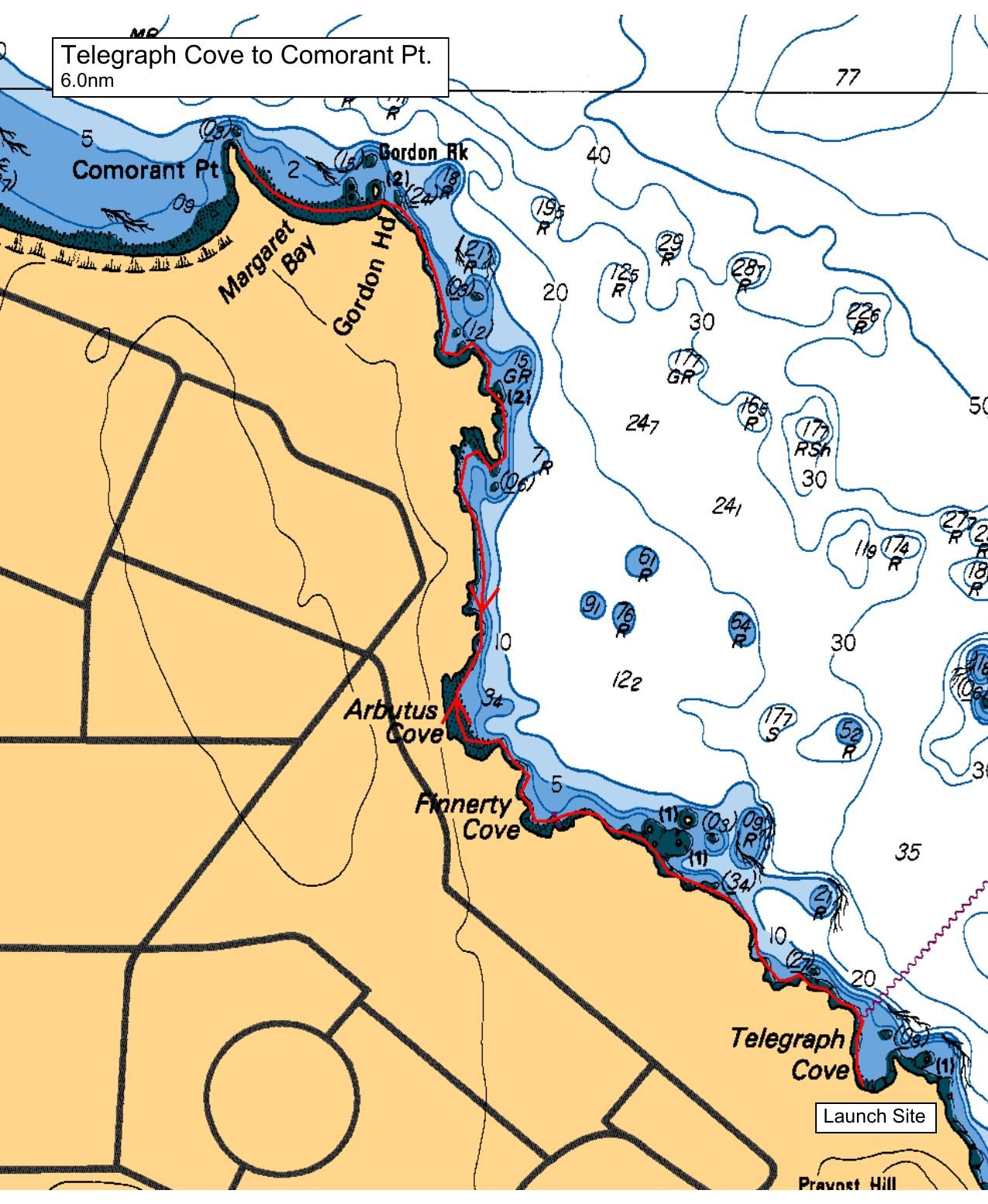
After our shore talk we will launch and follow the Gordon Head coastline, exploring the islets as we pass Finnerty Cove, Arbutus Cove, some sea caves, Glencoe Cove and Gordon Point. Rounding Gordon Head we will cross Margaret Bay to Cormorant Point. If conditions permit, we will round Cormorant Point into Cordova Bay and try to spot unusual birds and mammals on the quiet shoreline that fronts the Strangewood Estate. A few years ago a beaver was spotted here. We will then reverse course and land near the abandoned saltwater swimming pool at Margaret Bay. After lunch we will retrace our course back to Telegraph Bay.
Route plan B
If conditions dictate, we will move our launch site to the protected waters of Brentwood Bay and paddle to Todd Inlet and/or Mackenzie Bight.
Safety reminders
Always dress for the possibility of immersion and please bring a drybag containing a spare change of clothes. The drybag goes in your kayak with you, not in your car at the launch site. Please bring a lunch or snacks and sufficient beverage to keep you hydrated, as well as a thermos of something warm. Your paddle leader will introduce the plan and make sure everyone is comfortable with the requirements. Please stay off the water until the group is ready. If you have a VHF radio please bring it with you.
SISKA · Paddle · Relaxed
Printed Nov 9, 2026 11:03 AM · siska.ca/activities/1233
Telegraph Cove to Cormorant Point
Saturday, July 17, 2021 · 9:30 AM – 3:30 PM
Launch
Telegraph Cove4040 Lockehaven Dr
Destination
Cormorant Point
Distance
6 nm
Leader
Gary Jacek
Route plan A
After our shore talk we will launch and follow the Gordon Head coastline, exploring the islets as we pass Finnerty Cove, Arbutus Cove, some sea caves, Glencoe Cove and Gordon Point. Rounding Gordon Head we will cross Margaret Bay to Cormorant Point. If conditions permit, we will round Cormorant Point into Cordova Bay and try to spot unusual birds and mammals on the quiet shoreline that fronts the Strangewood Estate. A few years ago a beaver was spotted here. We will then reverse course and land near the abandoned saltwater swimming pool at Margaret Bay. After lunch we will retrace our course back to Telegraph Bay.
Route plan B
If conditions dictate, we will move our launch site to the protected waters of Brentwood Bay and paddle to Todd Inlet and/or Mackenzie Bight.
Route map
Telegraph Cove to Cormorant Point · Saturday, July 17, 2021