Paddle Energizer

Maple Bay Rowing Club to Burgoyne Bay

When Sunday, June 1, 2025 9:30 AM – 3:30 PM
Location Maple Bay Rowing Club
1 of 11 open Free
Destination Burgoyne Bay
Trip style Day
Experience Level 1
Distance 11.2 nm
Route plan A

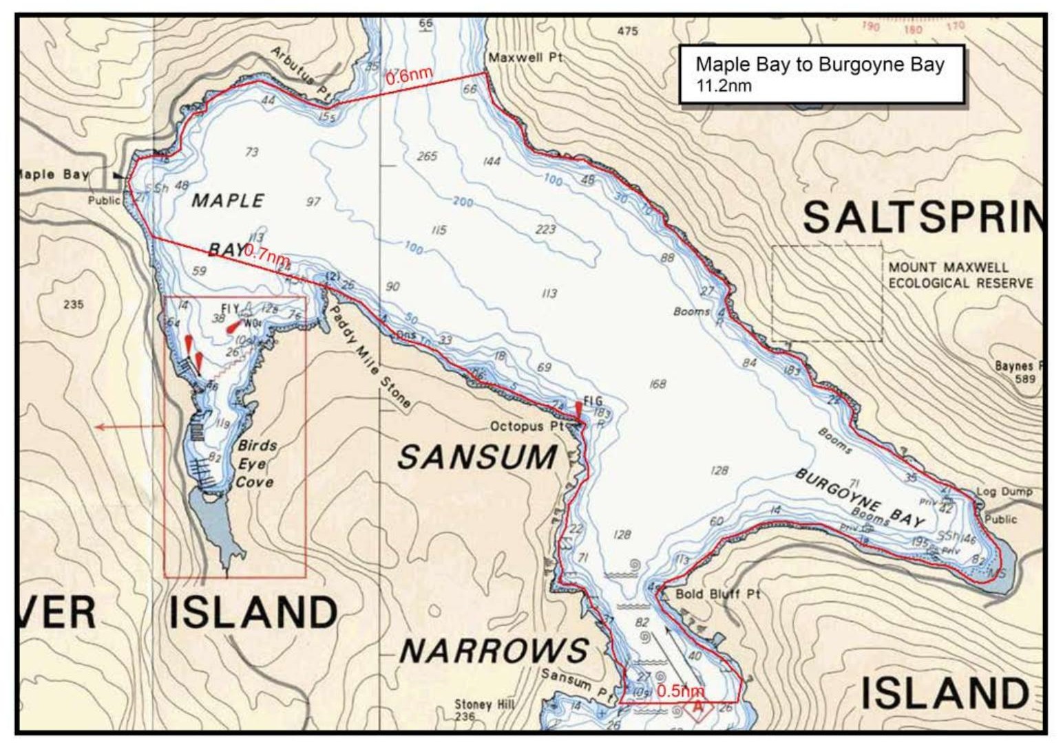
We will leave the launching point at the Maple Bay Rowing Club and public boat ramp and head over the mouth of Maple Bay to the shoreline leading to Octopus Pt. After Octopus Pt, we will noodle past the cliffs along Sansum Narrows. At Sansum Pt, we will cross over the narrows to Bold Bluff Pt on Salt Spring Island. We will then do more noodling along the south shoreline in Burgoyne Bay and then have lunch at the head of the bay. After lunch we can then noodle along the shoreline under Mt Maxwell leading to Maxwell Pt. The entirety of Burgoyne Bay is a provincial protected area (including Mt Maxwell Provincial Park. It really feels like you are a remote and natural setting, but yet only a few miles away from civilization. Our final destination is crossing over the channel to Arbutus Pt- at the mouth of Maple Bay, before reaching the boat ramp.

Route plan B

We can minimize the crossings (if too windy) by staying close to the shoreline along Sansum Narrows to some small pocket beaches near Grouse Hill in the narrows.

Safety reminders

Always dress for the possibility of immersion and please bring a drybag containing a spare change of clothes. The drybag goes in your kayak with you, not in your car at the launch site. Please bring a lunch or snacks and sufficient beverage to keep you hydrated, as well as a thermos of something warm. Your paddle leader will introduce the plan and make sure everyone is comfortable with the requirements. Please stay off the water until the group is ready. If you have a VHF radio please bring it with you.

Maple Bay Rowing Club tide/current reference

Sources & licences

Tide & current predictions

CHS provides tide heights and current predictions. Secondary current stations are estimates; large-tide estimates are identified separately. Tide turns and slack water are independent. Conditions along the route vary with location.

CHS atlas & lookup licences

Canadian Atlas of Tidal Currents, Volume 3: Juan de Fuca Strait to Strait of Georgia (2016), Canadian Hydrographic Service, Fisheries and Oceans Canada. © Her Majesty the Queen in Right of Canada, 2022.

Map images are reproduced from the CHS publication and selected for the date and time shown. The publication permits noncommercial reproduction in any format; commercial reproduction requires prior written permission from CHS. This viewer is not an official CHS publication and is not to be used for navigation.

Current Atlas Lookup Tables: Juan de Fuca Strait to Strait of Georgia by Emanuel Borsboom. SISKA adapts the tables to show selected hours and atlas page numbers. The original tables and these adapted tables are provided under Creative Commons Attribution-NonCommercial-ShareAlike 2.5 Canada (CC BY-NC-SA 2.5 CA).

Dewey atlas attribution

Salish Sea Tidal Current Atlas and calendar lookup tables by Richard K. Dewey, self-published. The selected volume and map number are shown in the viewer. SISKA displays extracted map images and selects them using the author's lookup tables.

For recreational reference only. Not for navigation. These products are not endorsed by CHS or NOAA and are not official Canadian or US government publications. Use current official charts and publications for navigation.

Confirm

Confirm action

Are you sure?

SISKA · Paddle · Energizer

Printed Nov 9, 2026 10:59 AM · siska.ca/activities/1550

Maple Bay Rowing Club to Burgoyne Bay

Sunday, June 1, 2025 · 9:30 AM – 3:30 PM

Launch
Maple Bay Rowing ClubDimview St
Destination
Burgoyne Bay
Distance
11.2 nm
Leader
Dave Chater

Route plan A

We will leave the launching point at the Maple Bay Rowing Club and public boat ramp and head over the mouth of Maple Bay to the shoreline leading to Octopus Pt. After Octopus Pt, we will noodle past the cliffs along Sansum Narrows. At Sansum Pt, we will cross over the narrows to Bold Bluff Pt on Salt Spring Island. We will then do more noodling along the south shoreline in Burgoyne Bay and then have lunch at the head of the bay. After lunch we can then noodle along the shoreline under Mt Maxwell leading to Maxwell Pt. The entirety of Burgoyne Bay is a provincial protected area (including Mt Maxwell Provincial Park. It really feels like you are a remote and natural setting, but yet only a few miles away from civilization. Our final destination is crossing over the channel to Arbutus Pt- at the mouth of Maple Bay, before reaching the boat ramp.

Route plan B

We can minimize the crossings (if too windy) by staying close to the shoreline along Sansum Narrows to some small pocket beaches near Grouse Hill in the narrows.